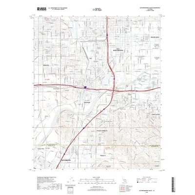
2018 Map of San Bernardino South
USGS Topo · Published 2018About this map
San Bernardino and its southern neighboring cities are depicted in this 2018 survey at the height of their modern expansion. This corridor between the Box Springs Mountains and the La Loma Hills is defined by a dense intersection of historical transit and water infrastructure. The Santa Ana River and San Timoteo Wash traverse the valley floor, alongside the modern Governor Edmund G Brown Jr California Aqueduct and the historical Mission Zanja watercourse. These irrigation and flood control systems sit adjacent to the heavy industrial rail lines of the BNSF Railway, which serves the major logistics hub at West Colton. Genealogists will find several notable burial grounds, including the historic Pioneer Memorial Cemetery and the Home of Eternity Cemetery, while the presence of institutions like Loma Linda University and San Bernardino Valley College highlights the region's educational development.
Find a feature on this map
113 named features on this map. Tap any name to fly to it.
Don’t see what you’re looking for? This feature index may not catch every label — zoom into the map to look around manually.
Map Details
Editions of this 2018 San Bernardino South Map
This is the sole edition of this map. No revisions or reprints were ever made.
Other maps of this area

1896 · San Bernardino
USGS Topo · 1:62,500

1898 · San Bernardino
USGS Topo · 1:62,500

1899 · Redlands
USGS Topo · 1:62,500

1901 · Southern California Sheet No. 1
USGS Topo · 1:250,000

1901 · San Bernardino
USGS Topo · 1:62,500

1901 · Redlands
USGS Topo · 1:62,500

1901 · Elsinore
USGS Topo · 1:125,000

1901 · Riverside
USGS Topo · 1:62,500

1904 · Southern California Sheet No. 1
USGS Topo · 1:250,000

1936 · Devore
USGS Topo · 1:31,680