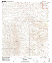
1996 Map of San Cayetano Mountains
USGS Topo · Published 2002About this map
Luis Maria Baca Float No 3 dominates this landscape in southern Arizona, representing one of the unique Mexican land grants that survived into modern cartography. The high terrain of the San Cayetano Mountains and the Grosvenor Hills is marked by early mining activity, including the Tubutama Mine, a Prospect, and several unnamed Mine sites. The presence of a small Cem and the Salero Ranch indicates a history of localized settlement and ranching in an area where water is a critical resource, evidenced by numerous tanks and springs like Coal Mine Spring and Tennis Spring. Protected lands such as the Coronado National Forest and the Sonoita Creek State Natural Area preserve the rugged drainage systems of Josephine Canyon and Fresno Canyon.
Find a feature on this map
33 named features on this map. Tap any name to fly to it.
Don’t see what you’re looking for? This feature index may not catch every label — zoom into the map to look around manually.
Map Details
Editions of this 1996 San Cayetano Mountains Map
This is the sole edition of this map. No revisions or reprints were ever made.
Other maps of this area

1904 · Patagonia
USGS Topo · 1:125,000

1905 · Patagonia
USGS Topo · 1:125,000

1905 · Nogales
USGS Topo · 1:125,000

1920 · Arivaca
USGS Topo · 1:125,000

1921 · Old Glory
USGS Topo · 1:125,000

1922 · Agus Caliente
USGS Topo · 1:62,500

1933 · Calabasas
USGS Topo · 1:62,500

1939 · Tubac
USGS Topo · 1:62,500

1942 · Ruby
USGS Topo · 1:62,500

1943 · Old Glory
USGS Topo · 1:125,000