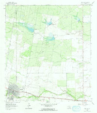
1963 Map of San Diego
USGS Topo · Published 1964About this map
San Diego serves as the focal point of this South Texas landscape, situated at the boundary of Duval Co and Jim Wells Co. During the early 1960s, the town's social and educational infrastructure is clearly visible, featuring the Parr Sch, High Sch, and local Cem. The surrounding terrain is defined by a network of ephemeral watercourses and early water management structures, including Muerto Creek, Resaca de Enmedio, and the sequential Chiltipin-San Fernando Dam No 8 and Chiltipin-San Fernando Dam No 9.
Find a feature on this map
21 named features on this map. Tap any name to fly to it.
Don’t see what you’re looking for? This feature index may not catch every label — zoom into the map to look around manually.
Map Details
Editions of this 1963 San Diego Map
2 editions found
Other maps of this area

1917 · Ben Bolt
USGS Topo · 1:62,500

1920 · San Diego
USGS Topo · 1:62,500

1956 · Benavides
USGS Topo · 1:62,500

1956 · Rosita Ranch
USGS Topo · 1:62,500

1956 · Laredo
USGS Topo · 1:250,000

1963 · San Diego NE
USGS Topo · 1:24,000

1963 · San Diego
USGS Topo · 1:24,000
1963 · Shaeffer Ranch
USGS Topo · 1:24,000
1963 · Alice North
USGS Topo · 1:24,000

1963 · Ben Bolt NW
USGS Topo · 1:24,000