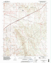
1990 Map of San Felipe Pueblo NE
USGS Topo · Published 1996About this map
The Santo Domingo Indian Reservation dominates the landscape of this Sandoval County quadrangle, showing the intersection of tribal lands and essential watercourses in the high desert. The map captures the tribal community's layout, specifically centering on the Santo Domingo School and a nearby Athletic Field along the northern edge. The hydrology is a primary feature of the region, defined by the winding course of Galisteo Creek and a network of ephemeral drainages including Arroyo de la Vega de los Tanos and Arroyo del Tuerto. These arroyos indicate the natural drainage patterns toward the Rio Grande valley just beyond the map boundaries. The transition into the San Felipe Indian Reservation Boundary to the south and west illustrates the contiguous nature of these sovereign lands, while numerous small Prospects and individual Springs highlight the localized natural resources and water sources vital to the area.
Find a feature on this map
22 named features on this map. Tap any name to fly to it.
Don’t see what you’re looking for? This feature index may not catch every label — zoom into the map to look around manually.
Map Details
Editions of this 1990 San Felipe Pueblo NE Map
This is the sole edition of this map. No revisions or reprints were ever made.
Other maps of this area

1892 · San Pedro
USGS Topo · 1:125,000

1892 · Santa Clara
USGS Topo · 1:125,000

1953 · Santo Domingo Pueblo
USGS Topo · 1:24,000

1953 · Tetilla Peak
USGS Topo · 1:24,000

1953 · Santo Domingo Pueblo SW
USGS Topo · 1:24,000

1953 · Agua Fria
USGS Topo · 1:62,500

1953 · Santo Domingo Pueblo
USGS Topo · 1:62,500

1954 · San Felipe Pueblo
USGS Topo · 1:24,000

1954 · Placitas
USGS Topo · 1:24,000

1954 · San Felipe Pueblo NE
USGS Topo · 1:24,000