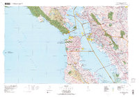
1978 Map of San Francisco
USGS Topo · Published 1979About this map
San Francisco and the greater Bay Area are documented here just before the close of the 1970s, showcasing a landscape of intense urban density and extensive military and federal land holdings. The map highlights the significant footprint of the Presidio Military Res and Fort Mason at the city's northern edge, alongside the strictly defined grounds of San Quentin. The regional transportation network is anchored by the Southern Pacific railroad lines and the massive spans of the Golden Gate Bridge and the San Francisco-Oakland Bay Bridge.
Find a feature on this map
211 named features on this map. Tap any name to fly to it.
Don’t see what you’re looking for? This feature index may not catch every label — zoom into the map to look around manually.
Map Details
Editions of this 1978 San Francisco Map
2 editions found
Other maps of this area

1889 · San Jose
USGS Topo · 1:62,500

1892 · San Mateo
USGS Topo · 1:62,500

1895 · San Francisco
USGS Topo · 1:62,500

1896 · San Mateo
USGS Topo · 1:62,500

1896 · Carquinez Strait
USGS Topo · 1:62,500

1896 · Mt. Diablo
USGS Topo · 1:62,500

1897 · San Jose
USGS Topo · 1:62,500

1897 · Concord
USGS Topo · 1:62,500

1897 · Palo Alto
USGS Topo · 1:62,500

1897 · Tamalpais
USGS Topo · 1:62,500