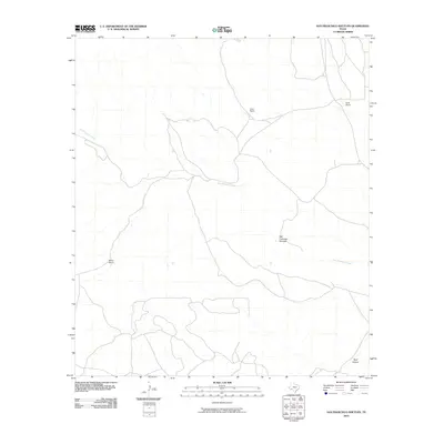
2010 Map of San Francisco Shutups
USGS Topo · Published 2010About this map
San Francisco Creek meanders through this portion of Brewster County, carving a path through the distinct terrain of the San Francisco Shutups. The landscape is defined by its isolation and the presence of established grazing operations, represented by the Clark Ranch, Keith Ranch, and Martin Ranch. These named homesteads provide a point of reference in an otherwise sparsely populated region of West Texas. To the southeast, the topography descends toward Beef Canyon, illustrating the drainage patterns that dominate this arid environment. The map details the network of unpaved roads and tracks that connect these remote ranches, offering a clear record of land use and navigation in the Big Bend region during the early 21st century.
Find a feature on this map
6 named features on this map. Tap any name to fly to it.
Don’t see what you’re looking for? This feature index may not catch every label — zoom into the map to look around manually.
Map Details
Editions of this 2010 San Francisco Shutups Map
This is the sole edition of this map. No revisions or reprints were ever made.
Other maps of this area

1918 · Dove Mountain
USGS Topo · 1:62,500

1918 · Bullis Gap
USGS Topo · 1:62,500

1920 · Longfellow
USGS Topo · 1:125,000

1954 · Fort Stockton
USGS Topo · 1:250,000

1958 · Fort Stockton
USGS Topo · 1:250,000

1959 · Emory Peak
USGS Topo · 1:250,000

1965 · Emory Peak
USGS Topo · 1:250,000

1968 · Big Brindle Canyon
USGS Topo · 1:24,000

1968 · Fresno Creek
USGS Topo · 1:24,000
1968 · Tesnus SE
USGS Topo · 1:24,000