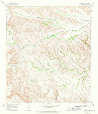
1968 Map of Tesnus SE
USGS Topo · Published 1971About this map
The Southern Pacific railroad cuts through the high desert of Brewster County, establishing a vital transportation corridor through this arid landscape. This 1968 survey highlights the small settlement of Rosenfeld and the nearby Cox Landing Field, illustrating how aviation and rail infrastructure supported this remote ranching region. The terrain is defined by a series of significant drainages, including Cox Creek and Maxon Creek, which carve deep paths through the topography toward the southwest.
Find a feature on this map
14 named features on this map. Tap any name to fly to it.
Don’t see what you’re looking for? This feature index may not catch every label — zoom into the map to look around manually.
Map Details
Editions of this 1968 Tesnus SE Map
2 editions found
Other maps of this area

1918 · Dove Mountain
USGS Topo · 1:62,500

1918 · Bullis Gap
USGS Topo · 1:62,500

1920 · Longfellow
USGS Topo · 1:125,000

1954 · Fort Stockton
USGS Topo · 1:250,000

1958 · Fort Stockton
USGS Topo · 1:250,000

1959 · Emory Peak
USGS Topo · 1:250,000

1965 · Emory Peak
USGS Topo · 1:250,000

1968 · Housetop Mountains
USGS Topo · 1:24,000

1968 · Tesnus
USGS Topo · 1:24,000

1968 · Fresno Creek
USGS Topo · 1:24,000