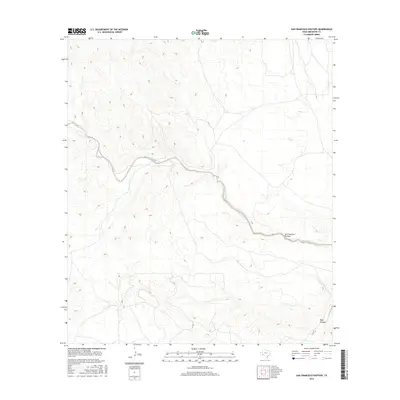
2016 Map of San Francisco Shutups
USGS Topo · Published 2016About this map
San Francisco Creek carves a winding path through this Brewster County landscape, defining the primary drainage system of the area. The terrain is characterized by the San Francisco Shutups, a distinct topographic narrowing where the creek passes through high ground. In the southeast, Beef Canyon provides a significant tributary draw into the main creek bed. This 2016 survey reflects the sparse, high-desert character of the Trans-Pecos region, where roads are infrequent and the land is shaped by seasonal water flow and stark elevation changes. The map offers a modern look at this corner of West Texas, useful for understanding contemporary land use and natural water features in a region defined by its geology.
Find a feature on this map
3 named features on this map. Tap any name to fly to it.
Don’t see what you’re looking for? This feature index may not catch every label — zoom into the map to look around manually.
Map Details
Editions of this 2016 San Francisco Shutups Map
This is the sole edition of this map. No revisions or reprints were ever made.
Other maps of this area

1918 · Dove Mountain
USGS Topo · 1:62,500

1918 · Bullis Gap
USGS Topo · 1:62,500

1920 · Longfellow
USGS Topo · 1:125,000

1954 · Fort Stockton
USGS Topo · 1:250,000

1958 · Fort Stockton
USGS Topo · 1:250,000

1959 · Emory Peak
USGS Topo · 1:250,000

1965 · Emory Peak
USGS Topo · 1:250,000

1968 · Big Brindle Canyon
USGS Topo · 1:24,000

1968 · Fresno Creek
USGS Topo · 1:24,000
1968 · Tesnus SE
USGS Topo · 1:24,000