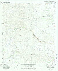
1983 Map of San Francisco Shutups
USGS Topo · Published 1984About this map
Slaughter Ranch stands as a primary focal point in this remote corner of Brewster County, where the desert landscape is defined by the unique geological passage of the San Francisco Shutups. This narrow canyon formation marks a dramatic constriction along the San Francisco Creek, an area where the watercourse cuts through resistant rock layers. The map reveals the infrastructure of isolated ranching life in the late twentieth century, including a Jeep Trail that navigates the difficult terrain and designated Landing Strips that provide essential aerial access to this high-desert region. To the south, the deep incision of Beef Canyon further illustrates the complex drainage systems that characterize this part of the Trans-Pecos, showing how water has shaped the rugged Texas geography over time.
Find a feature on this map
11 named features on this map. Tap any name to fly to it.
Don’t see what you’re looking for? This feature index may not catch every label — zoom into the map to look around manually.
Map Details
Editions of this 1983 San Francisco Shutups Map
This is the sole edition of this map. No revisions or reprints were ever made.
Other maps of this area

1918 · Dove Mountain
USGS Topo · 1:62,500

1918 · Bullis Gap
USGS Topo · 1:62,500

1920 · Longfellow
USGS Topo · 1:125,000

1954 · Fort Stockton
USGS Topo · 1:250,000

1958 · Fort Stockton
USGS Topo · 1:250,000

1959 · Emory Peak
USGS Topo · 1:250,000

1965 · Emory Peak
USGS Topo · 1:250,000

1968 · Big Brindle Canyon
USGS Topo · 1:24,000

1968 · Fresno Creek
USGS Topo · 1:24,000
1968 · Tesnus SE
USGS Topo · 1:24,000