
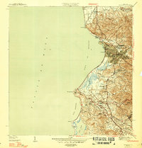
1950 Map of San German NO
USGS Topo · Published 1950About this map
Agricultural life in mid-century San Germán revolves around the fertile plains of the Río Guanajibo and its many tributaries, including the Río Viejo and Río Rosario. The landscape is dominated by large estates such as Hacienda Julia, Hacienda Margarita, and Hacienda Coto, which are serviced by the vital American Railroad line cutting through the central valley. In the north, the industrial presence of Central Eureka stands as a focal point for the regional sugar economy, while the southern terrain rises into the complex topography of Llanos Tuna and Cotui. Local community infrastructure is anchored by the Escuela Segunda Unidad de Sabana Eneas, reflecting the educational development in rural barrios during this period. These varied elements illustrate a transition between the traditional plantation system and modernizing infrastructure like the Porto Rico Transmisión lines.
Find a feature on this map
31 named features on this map. Tap any name to fly to it.
Don’t see what you’re looking for? This feature index may not catch every label — zoom into the map to look around manually.
Map Details
Editions of this 1950 San German NO Map
This is the sole edition of this map. No revisions or reprints were ever made.
Other maps of this area

1935 · Puerto Real
USGS Topo · 1:25,000

1937 · San German
USGS Topo · 1:25,000

1937 · Puerto Real
USGS Topo · 1:25,000

1939 · Mayaguez
USGS Topo · 1:30,000

1941 · San German
USGS Topo · 1:30,000

1941 · Puerto Real
USGS Topo · 1:30,000

1941 · Rosario
USGS Topo · 1:30,000

1942 · Rosario
USGS Topo · 1:30,000
1947 · Mayaguez
USGS Topo · 1:30,000
1949 · Puerto Real SE
USGS Topo · 1:10,000