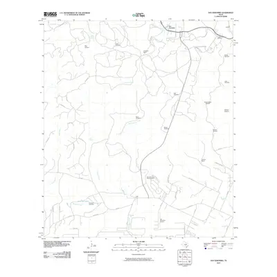
2010 Map of San Geronimo
USGS Topo · Published 2010About this map
San Geronimo and its surrounding hill country landscape appear here in the early 21st century, defined by a complex network of springs, canyons, and ranching infrastructure. The area is marked by numerous named water sources like Indian Mound Springs, Cherry Spring, and Blue Heaven, which feed into the drainage of San Geronimo Creek. Large landholdings such as Gallagher Ranch and Kallison Ranch dominate the topography, interspersed with deep cuts like Government Canyon and Walnut Canyon. The reliance on groundwater is evident through a series of named landmarks including the River Windmill, Moses Windmill, and Zapeta Windmill. Water management is further highlighted by the San Geronimo Recharge Dam and Schuchart Lake Dam. For genealogists, the Lee Cemetery and Cepeda Cemetery provide specific points of historical interest near the settlement of San Geronimo.
Find a feature on this map
56 named features on this map. Tap any name to fly to it.
Don’t see what you’re looking for? This feature index may not catch every label — zoom into the map to look around manually.
Map Details
Editions of this 2010 San Geronimo Map
This is the sole edition of this map. No revisions or reprints were ever made.
Other maps of this area

1953 · Culebra Hill
USGS Topo · 1:24,000

1953 · Helotes
USGS Topo · 1:24,000

1953 · Van Raub
USGS Topo · 1:24,000

1954 · San Antonio
USGS Topo · 1:250,000

1956 · Medina Lake
USGS Topo · 1:62,500

1957 · San Antonio
USGS Topo · 1:250,000

1958 · La Coste NE
USGS Topo · 1:24,000

1964 · Riomedina
USGS Topo · 1:24,000

1964 · Medina Lake
USGS Topo · 1:24,000
1966 · Culebra Hill
USGS Topo · 1:24,000