
1964 Map of Riomedina
USGS Topo · Published 1966About this map
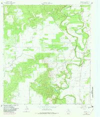
The Medina River carves a winding path through the eastern portion of this Medina County landscape, defining a terrain of sharp bends and riparian lowlands. In the mid-1960s, the small settlement of Riomedina sat near the river's edge, while further west, the historic community of Quihi anchored the area near Quihi Creek. The map reveals a complex hydraulic network where Yellow Creek, Elm Creek, and Oppossum Creek drain the central limestone hills toward the river valley.
Find a feature on this map
17 named features on this map. Tap any name to fly to it.
Don’t see what you’re looking for? This feature index may not catch every label — zoom into the map to look around manually.
Map Details
Editions of this 1964 Riomedina Map
2 editions found
Other maps of this area

1954 · San Antonio
USGS Topo · 1:250,000

1956 · New Fountain
USGS Topo · 1:62,500

1956 · Bandera
USGS Topo · 1:62,500

1956 · Medina Lake
USGS Topo · 1:62,500

1957 · San Antonio
USGS Topo · 1:250,000

1958 · La Coste
USGS Topo · 1:24,000

1958 · La Coste NE
USGS Topo · 1:24,000

1964 · Castroville
USGS Topo · 1:24,000

1964 · Timber Creek
USGS Topo · 1:24,000

1964 · Medina Lake
USGS Topo · 1:24,000