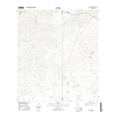
2016 Map of San Geronimo
USGS Topo · Published 2016About this map
San Geronimo and the surrounding Hill Country terrain are defined by a complex network of springs and seasonal creeks that feed into the Medina River basin. The landscape transitions from the high ground of Helotes Ridge and Blue Heaven down into deep incisions like Walnut Canyon and Wildcat Canyon. This era shows the residential expansion of the San Antonio outskirts, evidenced by a dense grid of county roads such as Co Rd 2740 and Co Rd 2727 west of the Medina and Bexar County line. Local history is preserved at the Cepeda Cemetery and Lee Cemetery, while the presence of the San Geronimo Airpark highlights the modern aerial infrastructure serving this rural-to-suburban corridor. Significant conservation land is visible at Government Canyon, protecting the vital aquifer recharge zones that begin at features like Indian Mound Springs and Pecan Spring.
Find a feature on this map
79 named features on this map. Tap any name to fly to it.
Don’t see what you’re looking for? This feature index may not catch every label — zoom into the map to look around manually.
Map Details
Editions of this 2016 San Geronimo Map
This is the sole edition of this map. No revisions or reprints were ever made.
Other maps of this area

1953 · Culebra Hill
USGS Topo · 1:24,000

1953 · Helotes
USGS Topo · 1:24,000

1953 · Van Raub
USGS Topo · 1:24,000

1954 · San Antonio
USGS Topo · 1:250,000

1956 · Medina Lake
USGS Topo · 1:62,500

1957 · San Antonio
USGS Topo · 1:250,000

1958 · La Coste NE
USGS Topo · 1:24,000

1964 · Riomedina
USGS Topo · 1:24,000

1964 · Medina Lake
USGS Topo · 1:24,000
1966 · Culebra Hill
USGS Topo · 1:24,000