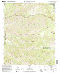
1995 Map of San Guillermo Mountain
USGS Topo · Published 2000About this map
San Guillermo Mountain stands as the central landmark of this mid-1990s forest survey, which details a landscape where administrative boundaries and wilderness designations intersect. The northern boundary follows the Lockwood Valley Road, serving as a transition into the more developed Plush Ranch area, while the southern reaches are dominated by the extensive Sespe Wilderness. The drainage of Piru Creek and its various forks, such as the South Fork and Cedar Creek, define the complex topography. Historically significant access routes like the Wagon Road and the Piedra Blanca Trail are clearly mapped, indicating the long-standing utility of these corridors for both transit and backcountry management. This edition is particularly useful for identifying established forest facilities including the Fish Bowls Campsite and the Gaging Station located near the confluence of several seasonal canyons.
Find a feature on this map
36 named features on this map. Tap any name to fly to it.
Don’t see what you’re looking for? This feature index may not catch every label — zoom into the map to look around manually.
Map Details
Editions of this 1995 San Guillermo Mountain Map
This is the sole edition of this map. No revisions or reprints were ever made.
Other maps of this area

1903 · Mt. Pinos
USGS Topo · 1:125,000

1942 · Wheeler Springs
USGS Topo · 1:24,000

1943 · Topatopa Mountains
USGS Topo · 1:24,000

1943 · Apache Canyon
USGS Topo · 1:24,000

1943 · San Guillermo
USGS Topo · 1:24,000

1943 · Sawmill Mountain
USGS Topo · 1:24,000

1943 · Cuddy Valley
USGS Topo · 1:24,000

1943 · Lockwood Valley
USGS Topo · 1:24,000

1943 · Lion Canyon
USGS Topo · 1:24,000

1943 · Reyes Peak
USGS Topo · 1:24,000