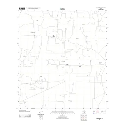
2012 Map of San Isidro
USGS Topo · Published 2012About this map
Cemeteries and remote oil fields define the landscape of this southern Texas interior, where family legacies are marked on the land through dozens of burial sites. Scattered settlements like San Isidro, Delmita, and Arkansas City anchor a grid of rural roads and farm-to-market routes, including FM-1017 and FM-755. The presence of numerous small cemeteries, such as Santa Elena Cem, Rancho Viejo Cem, and the Gonzales Cem, points to the deep-rooted ranching and farming history of the region.
Find a feature on this map
43 named features on this map. Tap any name to fly to it.
Don’t see what you’re looking for? This feature index may not catch every label — zoom into the map to look around manually.
Map Details
Editions of this 2012 San Isidro Map
This is the sole edition of this map. No revisions or reprints were ever made.
Other maps of this area

1938 · Agua Nueva
USGS Topo · 1:62,500

1938 · Sal Colorada
USGS Topo · 1:62,500

1939 · La Reforma
USGS Topo · 1:62,500

1939 · Encantada
USGS Topo · 1:62,500

1949 · Mc Allen
USGS Topo · 1:250,000

1954 · McAllen
USGS Topo · 1:250,000

1957 · Mc Allen
USGS Topo · 1:250,000

1962 · McAllen
USGS Topo · 1:250,000
1972 · Santa Elena SE
USGS Topo · 1:24,000
1972 · San Isidro
USGS Topo · 1:24,000