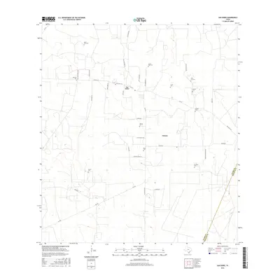
2016 Map of San Isidro
USGS Topo · Published 2016About this map
San Isidro and Delmita anchor this rural landscape in the Rio Grande Valley hinterlands, where the ranching heritage of South Texas is clearly inscribed across the terrain. The map reveals a dense network of family and community history, evidenced by an exceptional concentration of private and parish burial grounds. From Santa Elena Cem in the northwest to Gonzales Cem in the southeast, these sites often correlate with historic land grants and family estates. The road system, including Rich Road 1017 and FM 1017, connects these scattered settlements and cemeteries, while the eastern boundary tracks the transition from Starr County into Hidalgo County. The land is defined by winding tracks like War Loop and Old Church Rd, reflecting a settlement pattern based on ancestral ranching tracts rather than a rigid urban grid.
Find a feature on this map
39 named features on this map. Tap any name to fly to it.
Don’t see what you’re looking for? This feature index may not catch every label — zoom into the map to look around manually.
Map Details
Editions of this 2016 San Isidro Map
This is the sole edition of this map. No revisions or reprints were ever made.
Other maps of this area

1938 · Agua Nueva
USGS Topo · 1:62,500

1938 · Sal Colorada
USGS Topo · 1:62,500

1939 · La Reforma
USGS Topo · 1:62,500

1939 · Encantada
USGS Topo · 1:62,500

1949 · Mc Allen
USGS Topo · 1:250,000

1954 · McAllen
USGS Topo · 1:250,000

1957 · Mc Allen
USGS Topo · 1:250,000

1962 · McAllen
USGS Topo · 1:250,000
1972 · Santa Elena SE
USGS Topo · 1:24,000
1972 · San Isidro
USGS Topo · 1:24,000