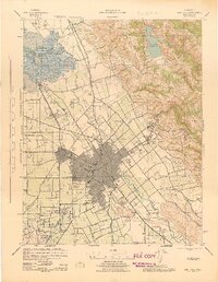
1943 Map of San Jose
USGS Topo · Published 1943About this map
The Guadalupe River and Coyote Creek anchor this mid-century survey of the Santa Clara Valley, revealing a landscape poised between its agrarian past and urban future. Substantial institutional sites like the Agnew State Hospital and the County Farm occupy large tracts of land north of San Jose, while the marshy northern reaches near Alviso are dominated by extensive Salt Beds and Goose Slough. The rail infrastructure is densely mapped, featuring the Southern Pacific and Western Pacific lines that facilitated the region's burgeoning fruit and industrial economy.
Find a feature on this map
60 named features on this map. Tap any name to fly to it.
Don’t see what you’re looking for? This feature index may not catch every label — zoom into the map to look around manually.
Map Details
Editions of this 1943 San Jose Map
This is the sole edition of this map. No revisions or reprints were ever made.
Other maps of this area

1889 · San Jose
USGS Topo · 1:62,500

1897 · San Jose
USGS Topo · 1:62,500

1897 · Mt. Hamilton
USGS Topo · 1:62,500

1897 · Palo Alto
USGS Topo · 1:62,500

1899 · San Jose
USGS Topo · 1:62,500

1899 · Palo Alto
USGS Topo · 1:62,500

1899 · Haywards
USGS Topo · 1:62,500

1902 · Santa Cruz
USGS Topo · 1:125,000

1906 · Pleasanton
USGS Topo · 1:62,500

1907 · Tesla
USGS Topo · 1:62,500