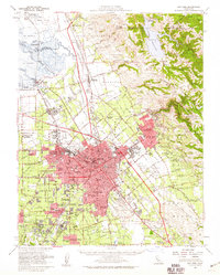
1953 Map of San Jose
USGS Topo · Published 1959About this map
Coyote Creek and the Guadalupe River converge toward the salt-rich tidelands of Alviso in this mid-century portrait of the Santa Clara Valley. The landscape reveals a region in transition, where sprawling orchards and ranch lands like Yerba Buena meet the expanding urban footprints of San Jose and Campbell. The footprint of the Agnew State Hospital and the busy San Jose Municipal Airport signal the area's growing institutional and infrastructure needs.
Find a feature on this map
74 named features on this map. Tap any name to fly to it.
Don’t see what you’re looking for? This feature index may not catch every label — zoom into the map to look around manually.
Map Details
Editions of this 1953 San Jose Map
This is the sole edition of this map. No revisions or reprints were ever made.
Other maps of this area

1889 · San Jose
USGS Topo · 1:62,500

1897 · San Jose
USGS Topo · 1:62,500

1897 · Mt. Hamilton
USGS Topo · 1:62,500

1897 · Palo Alto
USGS Topo · 1:62,500

1899 · San Jose
USGS Topo · 1:62,500

1899 · Palo Alto
USGS Topo · 1:62,500

1899 · Haywards
USGS Topo · 1:62,500

1902 · Santa Cruz
USGS Topo · 1:125,000

1906 · Pleasanton
USGS Topo · 1:62,500

1907 · Tesla
USGS Topo · 1:62,500