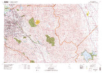
1978 Map of San Jose
USGS Topo · Published 1978About this map
The Santa Clara Valley serves as the focal point for this late-1970s survey, showing the rapid expansion of San Jose and surrounding communities like Sunnyvale and Campbell. The map captures a transition between the urbanized valley floor and the formidable terrain of the Santa Cruz Mountains to the west and the Sierra Azul range. To the east, the Lick Observatory sits atop the ridges, overlooking the sprawling suburban grid.
Find a feature on this map
55 named features on this map. Tap any name to fly to it.
Don’t see what you’re looking for? This feature index may not catch every label — zoom into the map to look around manually.
Map Details
Editions of this 1978 San Jose Map
This is the sole edition of this map. No revisions or reprints were ever made.
Other maps of this area

1889 · San Jose
USGS Topo · 1:62,500

1897 · San Jose
USGS Topo · 1:62,500

1897 · Mt. Hamilton
USGS Topo · 1:62,500

1897 · Palo Alto
USGS Topo · 1:62,500

1899 · San Jose
USGS Topo · 1:62,500

1899 · Palo Alto
USGS Topo · 1:62,500

1899 · Haywards
USGS Topo · 1:62,500

1902 · Santa Cruz
USGS Topo · 1:125,000

1906 · Pleasanton
USGS Topo · 1:62,500

1907 · Tesla
USGS Topo · 1:62,500