
1953 Map of San Luis Creek
USGS Topo · Published 1964About this map
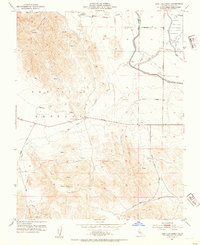
San Luis Ranch and Romero Ranch stand as prominent markers of the mid-century agricultural landscape in Merced County, where the transition from ranching traditions to modern irrigation is clearly visible. The eastern portion of the map is defined by an emerging water delivery network, including the Delta-Mendota Canal, the San Luis Canal, and a siphon and pumping station that signal the massive mid-century changes to California's hydraulic infrastructure. This interplay between the natural flow of San Luis Creek and the engineered waste-way illustrates the intensive management of resources during this era.
Find a feature on this map
27 named features on this map. Tap any name to fly to it.
Don’t see what you’re looking for? This feature index may not catch every label — zoom into the map to look around manually.
Map Details
Editions of this 1953 San Luis Creek Map
2 editions found
Historical Maps of Santa Nella Village Through Time
145 maps found

1916 Delta Ranch
Merced County, CA

1916 Hopeton
Merced County, CA

1916 Santa Rita Bridge
Merced County, CA

1918 Arena
Merced County, CA

1918 La Grand
Merced County, CA

1918 Lingard
Merced County, CA

1918 Sandy Mush
Merced County, CA

1918 Turner Ranch
Merced County, CA

1919 Haystack Mountain
Merced County, CA

1919 Ingomar
Merced County, CA

1919 Plainsberg
Merced County, CA

1919 San Luis Ranch
Merced County, CA

1920 Carrisalito Spring
Merced County, CA

1920 Pacheco Pass
Merced County, CA

1920 Santa Rita Bridge
Merced County, CA

1922 Charleston School
Merced County, CA

1922 Delta Ranch
Merced County, CA

1922 Howard Ranch
Merced County, CA

1922 Ortigalita
Merced County, CA

1922 Quien Sabe
Merced County, CA

1922 San Luis Creek
Merced County, CA

1922 Santa Rita Bridge
Merced County, CA

1940 Pacheco Pass
Merced County, CA

1940 Quien Sabe
Merced County, CA

1942 Athlone
Merced County, CA

1942 Irwin
Merced County, CA

1943 Ortigalita Peak
Merced County, CA

1946 Sandy Mush
Merced County, CA

1946 Santa Rita Park
Merced County, CA

1947 Ingomar
Merced County, CA

1947 Plainsburg
Merced County, CA

1947 San Luis Ranch
Merced County, CA

1948 Arena
Merced County, CA

1948 Delta Ranch
Merced County, CA

1948 Haystack Mountain
Merced County, CA

1948 Lingard
Merced County, CA

1948 Sandy Mush
Merced County, CA

1948 Santa Rita Bridge
Merced County, CA

1948 Turner Ranch
Merced County, CA

1948 Yosemite Lake
Merced County, CA

1953 Howard Ranch
Merced County, CA
1953 San Luis Creek
Merced County, CA

1955 Pacheco Pass
Merced County, CA

1956 Charleston School
Merced County, CA

1956 Ortigalita Peak
Merced County, CA

1956 Ortigalita Peak NW
Merced County, CA

1956 Quien Sabe
Merced County, CA

1960 Arena
Merced County, CA

1960 Ingomar
Merced County, CA

1960 Plainsburg
Merced County, CA

1961 Delta Ranch
Merced County, CA

1961 San Luis Ranch
Merced County, CA

1961 Turner Ranch
Merced County, CA

1962 Haystack Mtn.
Merced County, CA

1962 Sandy Mush
Merced County, CA

1962 Santa Rita Bridge
Merced County, CA

1962 Santa Rita Park
Merced County, CA

1962 Yosemite Lake
Merced County, CA

1968 Ruby Canyon
Merced County, CA

1969 Los Banos Valley
Merced County, CA

1969 Mariposa Peak
Merced County, CA

1969 Ortigalita Peak
Merced County, CA

1969 Ortigalita Peak NW
Merced County, CA

1969 San Luis Dam
Merced County, CA

1978 Mariposa Peak
Merced County, CA

1999 Haystack Mountain
Merced County, CA

1999 Howard Ranch
Merced County, CA

2000 Ortigalita Peak
Merced County, CA

2000 Ortigalita Peak NW
Merced County, CA

2012 Arena
Merced County, CA

2012 Charleston School
Merced County, CA

2012 Delta Ranch
Merced County, CA

2012 Haystack Mountain
Merced County, CA

2012 Howard Ranch
Merced County, CA

2012 Ingomar
Merced County, CA

2012 Los Banos Valley
Merced County, CA

2012 Mariposa Peak
Merced County, CA

2012 Ortigalita Peak
Merced County, CA

2012 Ortigalita Peak NW
Merced County, CA

2012 Pacheco Pass
Merced County, CA

2012 Plainsburg
Merced County, CA

2012 Ruby Canyon
Merced County, CA

2012 Sandy Mush
Merced County, CA

2012 San Luis Dam
Merced County, CA

2012 San Luis Ranch
Merced County, CA

2012 Santa Rita Bridge
Merced County, CA

2012 Turner Ranch
Merced County, CA

2012 Yosemite Lake
Merced County, CA

2015 Arena
Merced County, CA

2015 Charleston School
Merced County, CA

2015 Delta Ranch
Merced County, CA

2015 Haystack Mountain
Merced County, CA

2015 Howard Ranch
Merced County, CA

2015 Ingomar
Merced County, CA

2015 Los Banos Valley
Merced County, CA

2015 Mariposa Peak
Merced County, CA

2015 Ortigalita Peak
Merced County, CA

2015 Ortigalita Peak NW
Merced County, CA

2015 Pacheco Pass
Merced County, CA

2015 Plainsburg
Merced County, CA

2015 Ruby Canyon
Merced County, CA

2015 Sandy Mush
Merced County, CA

2015 San Luis Dam
Merced County, CA

2015 San Luis Ranch
Merced County, CA

2015 Santa Rita Bridge
Merced County, CA

2015 Turner Ranch
Merced County, CA

2015 Yosemite Lake
Merced County, CA

2018 Arena
Merced County, CA

2018 Charleston School
Merced County, CA

2018 Delta Ranch
Merced County, CA

2018 Haystack Mountain
Merced County, CA

2018 Howard Ranch
Merced County, CA

2018 Ingomar
Merced County, CA

2018 Los Banos Valley
Merced County, CA

2018 Mariposa Peak
Merced County, CA

2018 Ortigalita Peak
Merced County, CA

2018 Ortigalita Peak NW
Merced County, CA

2018 Pacheco Pass
Merced County, CA

2018 Plainsburg
Merced County, CA

2018 Ruby Canyon
Merced County, CA

2018 Sandy Mush
Merced County, CA

2018 San Luis Dam
Merced County, CA

2018 San Luis Ranch
Merced County, CA

2018 Santa Rita Bridge
Merced County, CA

2018 Turner Ranch
Merced County, CA

2018 Yosemite Lake
Merced County, CA

2021 Arena
Merced County, CA

2021 Charleston School
Merced County, CA

2021 Delta Ranch
Merced County, CA

2021 Haystack Mountain
Merced County, CA

2021 Howard Ranch
Merced County, CA

2021 Ingomar
Merced County, CA

2021 Los Banos Valley
Merced County, CA

2021 Mariposa Peak
Merced County, CA

2021 Ortigalita Peak
Merced County, CA

2021 Ortigalita Peak NW
Merced County, CA

2021 Pacheco Pass
Merced County, CA

2021 Plainsburg
Merced County, CA

2021 Ruby Canyon
Merced County, CA

2021 Sandy Mush
Merced County, CA

2021 San Luis Dam
Merced County, CA

2021 San Luis Ranch
Merced County, CA

2021 Santa Rita Bridge
Merced County, CA

2021 Turner Ranch
Merced County, CA

2021 Yosemite Lake
Merced County, CA