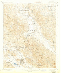
1897 Map of San Luis Obispo
USGS Topo · Published 1931About this map
San Luis Obispo serves as the focal point of this late nineteenth-century survey, sitting at the base of the Santa Lucia Range where the coastal hills meet the Laguna Valley. The Southern Pacific RR provides the primary industrial artery, winding through the difficult terrain of Cuesta Pass and connecting smaller depots like Goldtree and Serrano. This period captures the region before extensive suburban expansion, highlighting a landscape defined by large land grants such as Potrero de San Luis Obispo and Canada de los Osos. To the north, the headwaters of the Salinas River emerge near Santa Margarita, while peak-rich terrain is punctuated by distinctive landmarks like Cerro San Luis Obispo and Cerro Romauldo. The map illustrates a transitional era where traditional ranching boundaries still dictated the layout of emerging settlements like Atascadero.
Find a feature on this map
62 named features on this map. Tap any name to fly to it.
Don’t see what you’re looking for? This feature index may not catch every label — zoom into the map to look around manually.
Map Details
Editions of this 1897 San Luis Obispo Map
4 editions found
Other maps of this area

1897 · Port Harford
USGS Topo · 1:62,500

1897 · San Luis Obispo
USGS Topo · 1:62,500

1897 · Cayucos
USGS Topo · 1:62,500

1897 · Arroyo Grande
USGS Topo · 1:62,500

1900 · San Luis
USGS Topo · 1:125,000

1914 · Cholame
USGS Topo · 1:125,000

1915 · Cholame
USGS Topo · 1:125,000

1917 · Cholame
USGS Topo · 1:125,000

1919 · Paso Robles
USGS Topo · 1:62,500

1919 · Adelaida
USGS Topo · 1:62,500