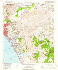
1948 Map of San Luis Rey
USGS Topo · Published 1961About this map
Mission San Luis Rey De Francia and the adjacent Academy of the Little Flower stand as prominent cultural landmarks in this late 1940s landscape, illustrating the deep-rooted religious and educational history of the valley. The coastal corridor is defined by the rapid growth of Oceanside and Carlsbad, where the Atchison Topeka and Santa Fe railroad and the Coast Highway parallel the Pacific shoreline. Inland, the transition from coastal bluffs to higher elevations like Cerro de la Calavera and San Francisco Pk reveals a mix of land uses, from the extensive Camp Joseph H Pendleton Naval Reservation in the north to the abandoned clay pits further south. Notable civic features including the Rosicrucian Hospital and Buddy Todd Memorial Park highlight the mid-century development of these seaside communities.
Find a feature on this map
61 named features on this map. Tap any name to fly to it.
Don’t see what you’re looking for? This feature index may not catch every label — zoom into the map to look around manually.
Map Details
Editions of this 1948 San Luis Rey Map
3 editions found
Other maps of this area

1893 · Oceanside
USGS Topo · 1:62,500

1893 · Escondido
USGS Topo · 1:62,500

1898 · Oceanside
USGS Topo · 1:62,500

1901 · Escondido
USGS Topo · 1:62,500

1901 · Oceanside
USGS Topo · 1:62,500

1901 · San Luis Rey
USGS Topo · 1:125,000

1904 · Southern California Sheet No. 2
USGS Topo · 1:250,000

1941 · Margarita Peak
USGS Topo · 1:62,500

1942 · Margarita Peak
USGS Topo · 1:62,500

1942 · Temecula
USGS Topo · 1:62,500