
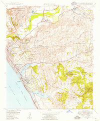
1948 Map of San Luis Rey
USGS Topo · Published 1966About this map
Mission San Luis Rey De Francia and the adjacent Academy of the Little Flower anchor the northern landscape of this San Diego County coastal region. The late-1940s postwar expansion is evident in the development of Oceanside and Carlsbad, where the Coast Highway and the Atchison Topeka and Santa Fe railroad corridor parallel the Gulf of Santa Catalina. The map illustrates a transitional period where agricultural interests like Rancho Guajome coexist with growing institutional and military footprints, including the southern edge of Camp Joseph H Pendleton Naval Reservation. Local industry and topography are noted through features like the Silica Pits, abandoned Clay Pits, and distinctive peaks such as Cerro de la Calavera. Ecological features like the Buena Vista Lagoon highlight the area's natural character before mid-century suburbanization fully transformed the coast.
Find a feature on this map
53 named features on this map. Tap any name to fly to it.
Don’t see what you’re looking for? This feature index may not catch every label — zoom into the map to look around manually.
Map Details
Editions of this 1948 San Luis Rey Map
3 editions found
Other maps of this area

1893 · Oceanside
USGS Topo · 1:62,500

1893 · Escondido
USGS Topo · 1:62,500

1898 · Oceanside
USGS Topo · 1:62,500

1901 · Escondido
USGS Topo · 1:62,500

1901 · Oceanside
USGS Topo · 1:62,500

1901 · San Luis Rey
USGS Topo · 1:125,000

1904 · Southern California Sheet No. 2
USGS Topo · 1:250,000

1941 · Margarita Peak
USGS Topo · 1:62,500

1942 · Margarita Peak
USGS Topo · 1:62,500

1942 · Temecula
USGS Topo · 1:62,500