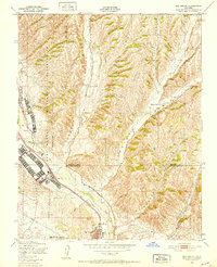
1948 Map of San Miguel
USGS Topo · Published 1952About this map
The Camp Roberts Military Reservation dominates the western landscape of this 1948 survey, establishing a significant military presence along the Salinas River corridor during the post-war era. The small settlement of San Miguel sits at the southern edge of the quadrangle, serving as a focal point for local commerce and transport where U. S. 101 parallels the Southern Pacific tracks. This transportation spine connects the town with the northern railroad outpost at McKay and the military grounds at Nacimiento. To the east, the terrain rises into the dissected ridges of the Diablo Range, marked by deep drainages like Vineyard Canyon and Mahoney Canyon. The distribution of rural landmarks, such as the Vineyard Sch and various scattered Windmill locations, reflects the region's agricultural reliance on the seasonal flows of Big Sandy Creek and its tributaries.
Find a feature on this map
20 named features on this map. Tap any name to fly to it.
Don’t see what you’re looking for? This feature index may not catch every label — zoom into the map to look around manually.
Map Details
Editions of this 1948 San Miguel Map
4 editions found
Other maps of this area

1919 · San Miguel
USGS Topo · 1:62,500

1919 · Paso Robles
USGS Topo · 1:62,500

1919 · Bradley
USGS Topo · 1:62,500

1919 · Adelaida
USGS Topo · 1:62,500

1932 · Adelaida
USGS Topo · 1:62,500

1941 · Bradley
USGS Topo · 1:62,500

1942 · Adelaida
USGS Topo · 1:62,500

1943 · Paso Robles
USGS Topo · 1:62,500

1947 · San Luis Obispo
USGS Topo · 1:250,000

1947 · San Miguel
USGS Topo · 1:62,500