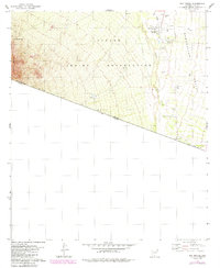
1979 Map of San Miguel
USGS Topo · Published 1984About this map
San Miguel serves as a focal point within the Papago Indian Reservation along the southern edge of the Baboquivari Valley. This 1970s landscape is defined by the sharp international boundary between the United States and Mexico, where the United States Mexico Jeep Trail skirts the jagged contours of Morena Mountain. Small settlements like Haivan Vaya and Hashan Chuchg are connected by seasonal water sources and stock management infrastructure, including the San Miguel Tank and numerous corrals.
Find a feature on this map
19 named features on this map. Tap any name to fly to it.
Don’t see what you’re looking for? This feature index may not catch every label — zoom into the map to look around manually.
Map Details
Editions of this 1979 San Miguel Map
2 editions found
Other maps of this area

1941 · Presumido Peak
USGS Topo · 1:62,500

1941 · Vamori
USGS Topo · 1:62,500

1943 · Fresnal
USGS Topo · 1:125,000

1943 · Presumido Peak
USGS Topo · 1:62,500

1943 · Vamori
USGS Topo · 1:62,500

1956 · Nogales
USGS Topo · 1:250,000

1958 · Nogales
USGS Topo · 1:250,000

1959 · Nogales
USGS Topo · 1:250,000
1979 · San Miguel
USGS Topo · 1:24,000
1979 · Caponera Peak
USGS Topo · 1:24,000
Featured Places
- Chukut Kuk District, AZ
- Haivan Vaya, Chukut Kuk District
- San Miguel, Chukut Kuk District
- Hashan Chuchg, Chukut Kuk District
- Pima County, AZ