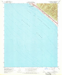
1968 Map of San Onofre Bluff
USGS Topo · Published 1970About this map
San Onofre Nuclear Generating Station dominates the northern coastline of this 1968 revision, marking a significant industrial presence along the Gulf of Santa Catalina. The map illustrates a narrow corridor of infrastructure squeezed between the Pacific and the rugged uplands of Camp Pendleton Marine Corps Base. This tight transportation belt includes the Atchison Topeka and Santa Fe railroad and the San Diego and Santa Fe Freeway, following the natural line of the Bluff and San Onofre Beach. Inland, the landscape is defined by the historic boundaries of the Las Flores Grant, where steep canyons meet the military installation. The presence of the Weigh Station and the small settlement of Agra further highlight the area's role as a vital transit link between major Southern California coastal hubs during the late 1960s.
Find a feature on this map
12 named features on this map. Tap any name to fly to it.
Don’t see what you’re looking for? This feature index may not catch every label — zoom into the map to look around manually.
Map Details
Editions of this 1968 San Onofre Bluff Map
3 editions found
Other maps of this area

1893 · Oceanside
USGS Topo · 1:62,500

1898 · Oceanside
USGS Topo · 1:62,500

1901 · Oceanside
USGS Topo · 1:62,500

1901 · San Luis Rey
USGS Topo · 1:125,000

1902 · Capistrano
USGS Topo · 1:125,000

1904 · Southern California Sheet No. 2
USGS Topo · 1:250,000

1906 · Capistrano
USGS Topo · 1:125,000

1941 · Margarita Peak
USGS Topo · 1:62,500

1942 · Margarita Peak
USGS Topo · 1:62,500

1942 · San Juan Capistrano
USGS Topo · 1:62,500
Featured Places
- San Clemente, CA
- Marine Corps Base Camp Pendleton, CA
- Agra, Marine Corps Base Camp Pendleton
- San Diego County, CA
- Orange County, CA