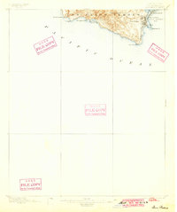
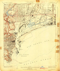
1896 Map of San Pedro
USGS Topo · Published 1899About this map
The hills of Los Palos Verdes dominate this coastal survey, rising to San Pedro Hill as they overlook the Pacific. Along the eastern shoreline, the industrial roots of San Pedro are clearly visible at the end of the nineteenth century. Two major rail lines, the L.A. Terminal R.R. and the S.P.R.R. (San Pedro Branch), converge on the harbor to service the growing maritime trade. The map documents a vanishing coastal geography, depicting island features like Rattlesnake Id. and Deadman Id. before decades of harbor development and dredging altered the San Pedro Bay waterfront. Inland, the landscape remains largely open, defined by topographical points such as Portuguese Pt. and the prominent Point Fermin LH, which stood as a primary navigational landmark for vessels entering the bay.
Find a feature on this map
18 named features on this map. Tap any name to fly to it.
Don’t see what you’re looking for? This feature index may not catch every label — zoom into the map to look around manually.
Map Details
Editions of this 1896 San Pedro Map
5 editions found
Other maps of this area

1896 · Redondo
USGS Topo · 1:62,500

1896 · Las Bolsas
USGS Topo · 1:62,500

1896 · San Pedro
USGS Topo · 1:62,500

1896 · Downey
USGS Topo · 1:62,500

1899 · Downey
USGS Topo · 1:62,500

1901 · Southern California Sheet No. 1
USGS Topo · 1:250,000

1902 · Downey
USGS Topo · 1:62,500

1904 · Southern California Sheet No. 1
USGS Topo · 1:250,000

1923 · Wilmington
USGS Topo · 1:24,000
1925 · Wilmington
USGS Topo · 1:24,000
Featured Places
- Los Angeles, CA
- Rancho Palos Verdes, CA
- Rolling Hills, CA
- La Rambla, CA
- Portuguese Bend, Rancho Palos Verdes