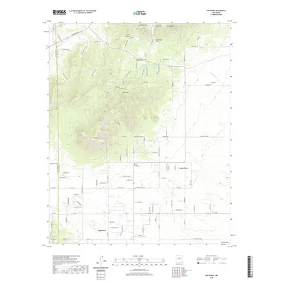
2020 Map of San Pedro
USGS Topo · Published 2020About this map
San Pedro Mtn and the adjacent San Pedro Mountains dominate the northern landscape of this Santa Fe County region. This modern survey illustrates a rugged terrain defined by sharp elevation changes, where peaks like Oro Quay Peak and South Mtn overlook a network of canyons and draws, including the Cañon del Agua and Hyer Draw. Residential expansion is evident in the southern half of the map, where the settlements of Cedar Grove and Edgewood are connected by a dense grid of local roads and larger thoroughfares like the Turquoise Trl. Genealogists and local historians can locate several significant burial sites, such as the San Pedro Cem, Hyer Cem, and Cedar Grove Cem, which serve as physical markers of the area's long-term settlement. The map also records natural features like the Cañon del Agua Springs and the drainage of the Cañada de la Narrias.
Find a feature on this map
64 named features on this map. Tap any name to fly to it.
Don’t see what you’re looking for? This feature index may not catch every label — zoom into the map to look around manually.
Map Details
Editions of this 2020 San Pedro Map
This is the sole edition of this map. No revisions or reprints were ever made.
Other maps of this area

1892 · San Pedro
USGS Topo · 1:125,000

1954 · Sandia Park
USGS Topo · 1:24,000

1954 · San Pedro
USGS Topo · 1:24,000

1954 · Sedillo
USGS Topo · 1:24,000

1954 · Hagan
USGS Topo · 1:24,000

1954 · Edgewood
USGS Topo · 1:24,000

1954 · San Felipe Pueblo
USGS Topo · 1:62,500

1956 · Edgewood
USGS Topo · 1:62,500

1958 · Albuquerque
USGS Topo · 1:250,000

1961 · Madrid
USGS Topo · 1:62,500