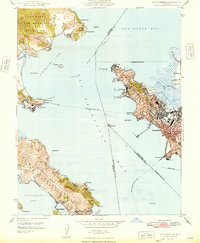
1948 Map of San Quentin
USGS Topo · Published 1948About this map
The maritime and industrial character of the north bay is documented in this 1948 survey, overseen by Governor Earl Warren and state engineer Edward Hyatt. The landscape is dominated by the State Penitentiary at San Quentin and the coastal operations of the Tiburon Naval Net Depot along the Tiburon Peninsula. On the eastern shore, the infrastructure of Richmond includes the Richmond Pier and the Atchison Topeka and Santa Fe railroad, while the industrial site at Winehaven stands along the rugged coastline of Pt San Pablo.
Find a feature on this map
53 named features on this map. Tap any name to fly to it.
Don’t see what you’re looking for? This feature index may not catch every label — zoom into the map to look around manually.
Map Details
Editions of this 1948 San Quentin Map
2 editions found
Other maps of this area

1895 · San Francisco
USGS Topo · 1:62,500

1897 · Tamalpais
USGS Topo · 1:62,500

1899 · San Francisco
USGS Topo · 1:62,500

1902 · Napa
USGS Topo · 1:125,000

1914 · Petaluma
USGS Topo · 1:62,500

1915 · San Francisco
USGS Topo · 1:62,500

1916 · Mare Island
USGS Topo · 1:62,500

1941 · Tamalpais
USGS Topo · 1:62,500

1942 · Mare Island
USGS Topo · 1:62,500

1942 · Petaluma
USGS Topo · 1:62,500