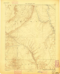
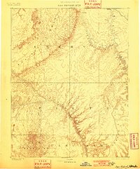
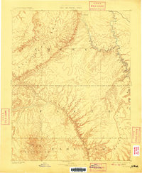
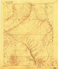
1885 Map of San Rafael
USGS Topo · Published 1896About this map
Director J.W. Powell oversaw this early triangulation and topographic study of southern Utah, capturing the desert landscape as it was understood in the late nineteenth century. The drainage systems of the Green River and the Fremont River dominate the eastern and southern portions of the sheet, carving through the dramatic geography of Labyrinth Canon and past the Orange Cliffs. The interior is defined by the massive San Rafael Swell, a geologic feature that rises above the surrounding San Rafael Valley. Sparse human presence is recorded at the rail crossings of Blake and the small settlement of Tidwell. To the southwest, the Henry Mountains rise abruptly, anchored by the peak of Mt Ellen. This survey serves as a fundamental record of the high desert before modern infrastructure, detailing the precise relationship between the twisting river beds and the prominent escarpments that defined travel in Emery, Piute, and Garfield counties.
Find a feature on this map
16 named features on this map. Tap any name to fly to it.
Don’t see what you’re looking for? This feature index may not catch every label — zoom into the map to look around manually.
Map Details
Editions of this 1885 San Rafael Map
5 editions found
Other maps of this area

1885 · San Rafael
USGS Topo · 1:250,000

1885 · Manti
USGS Topo · 1:250,000

1885 · East Tavaputs
USGS Topo · 1:250,000

1885 · La Sal
USGS Topo · 1:250,000

1885 · Fish Lake
USGS Topo · 1:250,000

1886 · Escalante
USGS Topo · 1:250,000

1886 · Henry Mountains
USGS Topo · 1:250,000

1886 · Price River
USGS Topo · 1:250,000

1886 · Abajo
USGS Topo · 1:250,000

1892 · Abajo
USGS Topo · 1:250,000