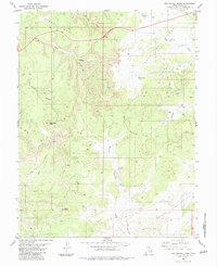
1983 Map of San Rafael Knob
USGS Topo · Published 1983About this map
San Rafael Knob dominates this high desert landscape, characterized by complex drainages and stark geologic formations. The area is marked by significant topographical landmarks such as Secret Mesa and the sweeping Head of Sinbad, while narrow corridors like Eagle Canyon and Devils Canyon cut through the terrain. Evidence of early prospector activity is visible in several Mine locations and scattered prospects found near Iron Wash, suggesting a history of mineral exploration in this isolated corner of Emery County. Natural landmarks like Ghost Rock, Dutchman Arch, and the Natural Arch provide essential orientation points for those navigating the numerous unnamed jeep trails. The inclusion of Family Butte and Rods Valley further highlights the distinct local nomenclature used by those who worked and traveled these basins before more modern infrastructure arrived.
Find a feature on this map
31 named features on this map. Tap any name to fly to it.
Don’t see what you’re looking for? This feature index may not catch every label — zoom into the map to look around manually.
Map Details
Editions of this 1983 San Rafael Knob Map
2 editions found
Other maps of this area

1885 · San Rafael
USGS Topo · 1:250,000

1952 · Wild Horse
USGS Topo · 1:62,500

1952 · San Rafael Knob
USGS Topo · 1:62,500

1953 · Stinking Spring Creek 2 SE
USGS Topo · 1:24,000

1953 · Temple Mtn
USGS Topo · 1:62,500

1954 · Stinking Spring Creek 1 NW
USGS Topo · 1:24,000

1954 · Stinking Spring Creek 3 NW
USGS Topo · 1:24,000

1954 · Stinking Spring Creek 4 NW
USGS Topo · 1:24,000

1954 · Stinking Spring Creek 2 SW
USGS Topo · 1:24,000

1954 · Stinking Spring Creek 2 NE
USGS Topo · 1:24,000