
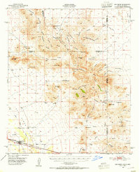
1950 Map of San Simon
USGS Topo · Published 1950About this map
The Peloncillo Mountains dominate the high desert terrain of this mid-century survey, which documents the borderlands between Arizona and New Mexico. The Southern Pacific railroad corridor serves as the primary artery for the valley, passing through the settlement of San Simon. The map preserves the locations of early frontier outposts and cattle operations, such as the Braidfoot Ranch and Willow Springs Ranch, alongside more ephemeral sites like Old Camp and the Old Stage Station (Ruins). This period reveals a landscape transitioning from the pioneer era to more modern land use, evidenced by the presence of Artesian Wells and mining sites like the Volcano Mine and National Mine. Local history is deeply etched into the geography through specific landmarks such as Giddings Grave and family-named peaks like McKenzie Peak, reflecting the area's legacy of ranching and territorial expansion.
Find a feature on this map
67 named features on this map. Tap any name to fly to it.
Don’t see what you’re looking for? This feature index may not catch every label — zoom into the map to look around manually.
Map Details
Editions of this 1950 San Simon Map
2 editions found
Other maps of this area

1917 · San Simon
USGS Topo · 1:125,000

1926 · Cochise Head
USGS Topo · 1:62,500

1926 · Orange Butte
USGS Topo · 1:62,500

1928 · Chenoweth
USGS Topo · 1:62,500

1928 · Bowie
USGS Topo · 1:62,500

1949 · Bowie
USGS Topo · 1:62,500

1950 · Bowie
USGS Topo · 1:62,500

1950 · Cochise Head
USGS Topo · 1:62,500

1950 · Vanar
USGS Topo · 1:62,500

1951 · Vanar
USGS Topo · 1:62,500