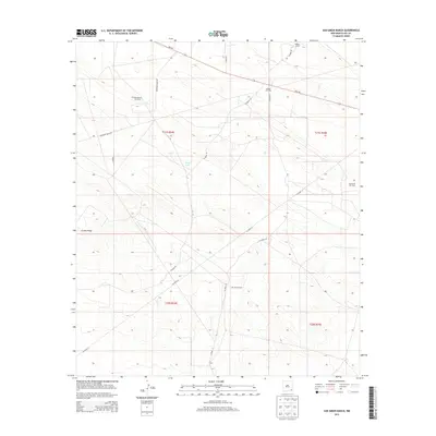
2013 Map of San Simon Ranch
USGS Topo · Published 2013About this map
The San Simon Ranch anchors this high-plains landscape in Lea County, New Mexico, where the legacy of ranching meets the industrial footprint of the Permian Basin. This 2013 survey documents a remote corner of the Llano Estacado defined by its energy production, notably the West Wilson Oil Field, Wilson Oil Field, and the San Simon Oil Field to the east. The terrain is marked by the distinctive elevation of Grama Ridge and the ephemeral basin of Floyd Lake. A network of county routes, including Co Road 30 and Co Road 31, connects these industrial sites and ranching outposts like Wilson Camp to the regional thoroughfare of NM-176. The map provides a detailed view of the township and range divisions that have structured land use in this arid region for generations.
Find a feature on this map
17 named features on this map. Tap any name to fly to it.
Don’t see what you’re looking for? This feature index may not catch every label — zoom into the map to look around manually.
Map Details
Editions of this 2013 San Simon Ranch Map
This is the sole edition of this map. No revisions or reprints were ever made.
Other maps of this area

1954 · Hobbs
USGS Topo · 1:250,000

1958 · Hobbs
USGS Topo · 1:250,000

1963 · Oil Center
USGS Topo · 1:62,500

1963 · Monument
USGS Topo · 1:62,500

1963 · Laguna Gatuna
USGS Topo · 1:62,500

1963 · Hat Mesa
USGS Topo · 1:62,500

1978 · Jal
USGS Topo · 1:100,000

1984 · Oil Center
USGS Topo · 1:24,000

1984 · Lea
USGS Topo · 1:24,000
1984 · Tip Top Wells
USGS Topo · 1:24,000