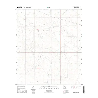
2017 Map of San Simon Ranch
USGS Topo · Published 2017About this map
San Simon Ranch serves as the namesake landmark for this portion of the Permian Basin, where the High Plains of Lea County meet the industrial demands of the modern energy sector. The landscape is characterized by its isolation and the practical infrastructure of the high desert, centered around a network of desert roads including Delaware Basin Rd and San Simon Rd. Natural topographic features like the Grama Ridge and the ephemeral Floyd Lake provide some of the few markers in an area otherwise defined by ranching boundaries and energy development. This 2017 survey details the section lines and township grids that organize this arid terrain, showing how historical ranching sites persist alongside contemporary transport routes like Sims Rd and Co Rd 32.
Find a feature on this map
13 named features on this map. Tap any name to fly to it.
Don’t see what you’re looking for? This feature index may not catch every label — zoom into the map to look around manually.
Map Details
Editions of this 2017 San Simon Ranch Map
This is the sole edition of this map. No revisions or reprints were ever made.
Other maps of this area

1954 · Hobbs
USGS Topo · 1:250,000

1958 · Hobbs
USGS Topo · 1:250,000

1963 · Oil Center
USGS Topo · 1:62,500

1963 · Monument
USGS Topo · 1:62,500

1963 · Laguna Gatuna
USGS Topo · 1:62,500

1963 · Hat Mesa
USGS Topo · 1:62,500

1978 · Jal
USGS Topo · 1:100,000

1984 · Oil Center
USGS Topo · 1:24,000

1984 · Lea
USGS Topo · 1:24,000
1984 · Tip Top Wells
USGS Topo · 1:24,000