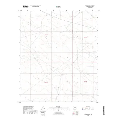
2020 Map of San Simon Ranch
USGS Topo · Published 2020About this map
San Simon Ranch serves as the namesake landmark for this portion of Lea County, a landscape defined by ranching life and desert geography in the Llano Estacado. The terrain is marked by the distinct elevation of Grama Ridge and the ephemeral basin of Floyd Lake, which together characterize the local drainage and grazing patterns. A sparse network of ranch roads provides the primary infrastructure for the area, including the San Simon Rd and Delaware Basin Rd. This survey reflects the modern intersection of traditional cattle ranching and industrial access, as seen through the grid of township and range boundaries like t21s r34e and t21s r35e. The map is particularly useful for understanding how water sources and land divisions shaped settlement in this high plains environment.
Find a feature on this map
50 named features on this map. Tap any name to fly to it.
Don’t see what you’re looking for? This feature index may not catch every label — zoom into the map to look around manually.
Map Details
Editions of this 2020 San Simon Ranch Map
This is the sole edition of this map. No revisions or reprints were ever made.
Other maps of this area

1954 · Hobbs
USGS Topo · 1:250,000

1958 · Hobbs
USGS Topo · 1:250,000

1963 · Oil Center
USGS Topo · 1:62,500

1963 · Monument
USGS Topo · 1:62,500

1963 · Laguna Gatuna
USGS Topo · 1:62,500

1963 · Hat Mesa
USGS Topo · 1:62,500

1978 · Jal
USGS Topo · 1:100,000

1984 · Oil Center
USGS Topo · 1:24,000

1984 · Lea
USGS Topo · 1:24,000
1984 · Tip Top Wells
USGS Topo · 1:24,000