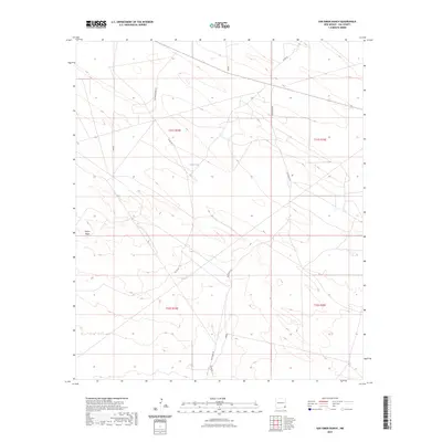
2023 Map of San Simon Ranch
USGS Topo · Published 2023About this map
Floyd Lake sits at the center of this corner of Lea County, a rare water feature in an arid landscape defined by expansive ranching and energy infrastructure. The terrain is marked by the Grama Ridge in the west, while the map's grid is dominated by a network of local connectors including San Simon Rd and Delaware Basin Rd. This survey, published by the U.S. Geological Survey, details the modern subdivision of the land into townships such as t21s r34e and t21s r35e. The presence of labels like Barrio and Sasimo alongside established county routes like Co Rd 30 illustrates the specialized naming conventions used for transit and property access in this New Mexico range country.
Find a feature on this map
13 named features on this map. Tap any name to fly to it.
Don’t see what you’re looking for? This feature index may not catch every label — zoom into the map to look around manually.
Map Details
Editions of this 2023 San Simon Ranch Map
This is the sole edition of this map. No revisions or reprints were ever made.
Other maps of this area

1954 · Hobbs
USGS Topo · 1:250,000

1958 · Hobbs
USGS Topo · 1:250,000

1963 · Oil Center
USGS Topo · 1:62,500

1963 · Monument
USGS Topo · 1:62,500

1963 · Laguna Gatuna
USGS Topo · 1:62,500

1963 · Hat Mesa
USGS Topo · 1:62,500

1978 · Jal
USGS Topo · 1:100,000

1984 · Oil Center
USGS Topo · 1:24,000

1984 · Lea
USGS Topo · 1:24,000
1984 · Tip Top Wells
USGS Topo · 1:24,000