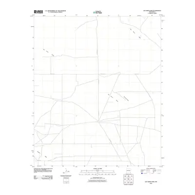
2010 Map of San Simon Sink
USGS Topo · Published 2010About this map
San Simon Sink defines this desert landscape in Lea County, New Mexico, where the topography of the Permian Basin reveals a notable depression and drainage pattern. The terrain is characterized by broad, low-lying features such as the San Simon Swale, which are flanked by prominent landforms including San Simon Ridge and Antelope Ridge to the southwest. The infrastructure shown in this 2010 survey reflects the region's ranching and energy-sector activity, with a network of corridors including County Rd-32 and County Rd-21 providing access across the arid plains. Notable locally named paths like Shell Rd suggest the presence of industrial traffic or specific land-use history within this isolated section of the state, where the natural sink and swale formations remain the most distinctive geographic markers.
Find a feature on this map
7 named features on this map. Tap any name to fly to it.
Don’t see what you’re looking for? This feature index may not catch every label — zoom into the map to look around manually.
Map Details
Editions of this 2010 San Simon Sink Map
This is the sole edition of this map. No revisions or reprints were ever made.
Other maps of this area

1954 · Hobbs
USGS Topo · 1:250,000

1958 · Hobbs
USGS Topo · 1:250,000

1963 · Oil Center
USGS Topo · 1:62,500

1963 · Hat Mesa
USGS Topo · 1:62,500

1973 · Bell Lake
USGS Topo · 1:24,000

1973 · Custer Mountain
USGS Topo · 1:24,000
1973 · Woodley Flat
USGS Topo · 1:24,000

1978 · Jal
USGS Topo · 1:100,000

1984 · Oil Center
USGS Topo · 1:24,000
1984 · Tip Top Wells
USGS Topo · 1:24,000