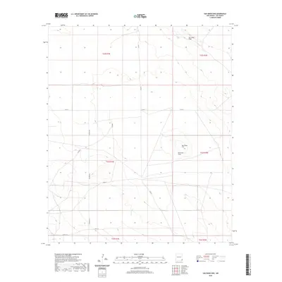
2020 Map of San Simon Sink
USGS Topo · Published 2020About this map
San Simon Sink defines the topography of this high plains landscape in Lea County, New Mexico. This region is characterized by subtle depression and elevation features, with the prominent San Simon Ridge overlooking the broad San Simon Swale. A network of rural and industrial roads, including Adobe Rd, Antelope Rd, and Shell Rd, crisscrosses the township boundaries of T22S through T24S, reflecting the region's cattle ranching and energy infrastructure. The presence of Keller Ln and several designated county roads like Co RD 32 and Co RD 21 suggests a landscape managed for resource access and transit between remote desert points.
Find a feature on this map
16 named features on this map. Tap any name to fly to it.
Don’t see what you’re looking for? This feature index may not catch every label — zoom into the map to look around manually.
Map Details
Editions of this 2020 San Simon Sink Map
This is the sole edition of this map. No revisions or reprints were ever made.
Other maps of this area

1954 · Hobbs
USGS Topo · 1:250,000

1958 · Hobbs
USGS Topo · 1:250,000

1963 · Oil Center
USGS Topo · 1:62,500

1963 · Hat Mesa
USGS Topo · 1:62,500

1973 · Bell Lake
USGS Topo · 1:24,000

1973 · Custer Mountain
USGS Topo · 1:24,000
1973 · Woodley Flat
USGS Topo · 1:24,000

1978 · Jal
USGS Topo · 1:100,000

1984 · Oil Center
USGS Topo · 1:24,000
1984 · Tip Top Wells
USGS Topo · 1:24,000