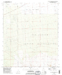
1992 Map of San Xavier Mission SW
USGS Topo · Published 1995About this map
The San Xavier Indian Reservation and Pascua Yaqui Indian Reservation dominate this landscape southwest of Tucson, as recorded in the early 1990s. The terrain transitions from the low-lying Avra Valley in the north toward the rising contours of the Tohono O'odham Nation. This area is characterized by a sparse network of ranching and utility infrastructure, including the J Bar M site and various water sources like the Water Tank and Well WT.
Find a feature on this map
10 named features on this map. Tap any name to fly to it.
Don’t see what you’re looking for? This feature index may not catch every label — zoom into the map to look around manually.
Map Details
Editions of this 1992 San Xavier Mission SW Map
This is the sole edition of this map. No revisions or reprints were ever made.
Other maps of this area

1920 · Arivaca
USGS Topo · 1:125,000

1925 · Samaniego Peak
USGS Topo · 1:62,500

1925 · San Xavier
USGS Topo · 1:62,500

1934 · Tucson Mountains
USGS Topo · 1:125,000

1939 · Twin Buttes
USGS Topo · 1:62,500

1940 · Palo Alto Ranch
USGS Topo · 1:62,500

1941 · Twin Buttes
USGS Topo · 1:62,500

1941 · Cocoraque Butte
USGS Topo · 1:62,500

1943 · Cocoraque Butte
USGS Topo · 1:62,500

1943 · Palo Alto Ranch
USGS Topo · 1:62,500