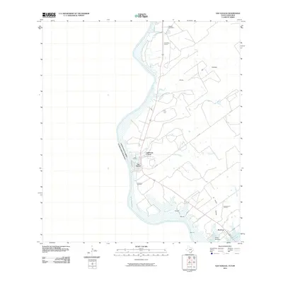
2010 Map of San Ygnacio
USGS Topo · Published 2010About this map
San Ygnacio sits on the high banks of the Rio Grande, serving as a focal point for this borderland geography where the river defines the international boundary between the United States and Mexico. This 2010 survey details a landscape where traditional settlements and newer developments like Valle Verde Colonia meet the fluctuating waters of the Falcon Reservoir. The area is marked by a deep sense of local lineage, evidenced by the presence of several burial sites including the Uribe Cemetery, Cementerio del Pueblo, and New Ramireno Cemetery.
Find a feature on this map
22 named features on this map. Tap any name to fly to it.
Don’t see what you’re looking for? This feature index may not catch every label — zoom into the map to look around manually.
Map Details
Editions of this 2010 San Ygnacio Map
This is the sole edition of this map. No revisions or reprints were ever made.
Other maps of this area

1942 · San Ygnacio
USGS Topo · 1:62,500

1949 · Mc Allen
USGS Topo · 1:250,000

1954 · McAllen
USGS Topo · 1:250,000

1956 · Zapata
USGS Topo · 1:62,500

1956 · Laredo
USGS Topo · 1:250,000

1957 · Mc Allen
USGS Topo · 1:250,000

1962 · McAllen
USGS Topo · 1:250,000
1979 · Zapata
USGS Topo · 1:24,000
1979 · Zapata NW
USGS Topo · 1:24,000
1979 · San Ygnacio
USGS Topo · 1:24,000