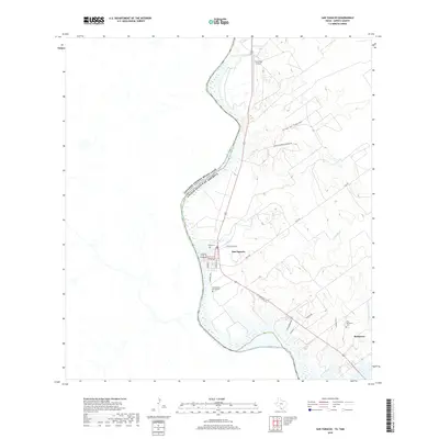
2019 Map of San Ygnacio
USGS Topo · Published 2019About this map
The Rio Grande serves as the international border between the United States and Mexico in this riverfront region of Zapata County. The settlement of San Ygnacio is the primary hub of activity, defined by a grid including Laredo St, Guerrero St, and Grant Ave. Local heritage is anchored by sites like Uribe Cem and the Cementerio del Pueblo, while the Corralitos Airport stands to the north along the main highway corridor. To the southeast, the smaller community of Ramireno is situated near several watercourses such as El Grullo Cr and Arroyo Zapilote. The landscape is etched by numerous drainages, including Arroyo San Francisco and Las Palomas Cr, reflecting the arid environment and the critical importance of the river for these borderlands communities.
Find a feature on this map
22 named features on this map. Tap any name to fly to it.
Don’t see what you’re looking for? This feature index may not catch every label — zoom into the map to look around manually.
Map Details
Editions of this 2019 San Ygnacio Map
This is the sole edition of this map. No revisions or reprints were ever made.
Other maps of this area

1942 · San Ygnacio
USGS Topo · 1:62,500

1949 · Mc Allen
USGS Topo · 1:250,000

1954 · McAllen
USGS Topo · 1:250,000

1956 · Zapata
USGS Topo · 1:62,500

1956 · Laredo
USGS Topo · 1:250,000

1957 · Mc Allen
USGS Topo · 1:250,000

1962 · McAllen
USGS Topo · 1:250,000
1979 · Zapata
USGS Topo · 1:24,000
1979 · Zapata NW
USGS Topo · 1:24,000
1979 · San Ygnacio
USGS Topo · 1:24,000