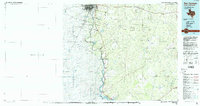
1985 Map of San Ygnacio
USGS Topo · Published 1993About this map
The Rio Grande serves as the international boundary between Texas and Tamaulipas in this 1980s-era topographical record of the borderlands. The landscape is defined by its drainage network, with dozens of named arroyos such as Arroyo Agua Azul and Arroyo Chargos feeding into the river. On the American side, the settlement pattern centers around the Texas Mexican RR corridor in the north, where small communities like Aguilares and Reiser are located, and along U.S. 83 which parallels the river down toward San Ygnacio.
Find a feature on this map
38 named features on this map. Tap any name to fly to it.
Don’t see what you’re looking for? This feature index may not catch every label — zoom into the map to look around manually.
Map Details
Editions of this 1985 San Ygnacio Map
3 editions found
Other maps of this area

1933 · Becerra Creek
USGS Topo · 1:62,500

1937 · Aguilete Creek
USGS Topo · 1:62,500

1938 · Cuevitas
USGS Topo · 1:62,500

1939 · Bruni
USGS Topo · 1:62,500

1939 · Randado
USGS Topo · 1:62,500

1940 · Aguilares
USGS Topo · 1:62,500

1940 · Randado
USGS Topo · 1:62,500

1940 · Mogotes Hill
USGS Topo · 1:62,500

1942 · San Ygnacio
USGS Topo · 1:62,500

1949 · Mc Allen
USGS Topo · 1:250,000