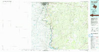
1985 Map of San Ygnacio
USGS Topo · Published 1993About this map
The Rio Grande serves as the dominant spine of this borderland survey, marking the international boundary between Texas and Mexico. Near the northern edge, the urban centers of Laredo and Nuevo Laredo straddle the river, while further south, the historic settlement of San Ygnacio sits on the riverbank amidst a landscape carved by numerous arroyos. To the east, the Texas Mexican RR cuts across the brush country, connecting the interior through small rail points like Aguilares and Lobo.
Find a feature on this map
49 named features on this map. Tap any name to fly to it.
Don’t see what you’re looking for? This feature index may not catch every label — zoom into the map to look around manually.
Map Details
Editions of this 1985 San Ygnacio Map
3 editions found
Other maps of this area

1933 · Becerra Creek
USGS Topo · 1:62,500

1937 · Aguilete Creek
USGS Topo · 1:62,500

1938 · Cuevitas
USGS Topo · 1:62,500

1939 · Bruni
USGS Topo · 1:62,500

1939 · Randado
USGS Topo · 1:62,500

1940 · Aguilares
USGS Topo · 1:62,500

1940 · Randado
USGS Topo · 1:62,500

1940 · Mogotes Hill
USGS Topo · 1:62,500

1942 · San Ygnacio
USGS Topo · 1:62,500

1949 · Mc Allen
USGS Topo · 1:250,000