
1984 Map of Sanborn
USGS Topo · Published 1984About this map
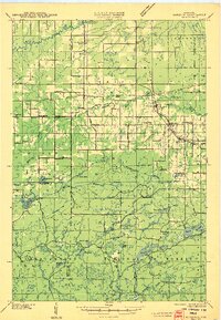
Sanborn sits as a central point of settlement in the north woods of Wisconsin, situated along an Old Railroad Grade that speaks to the region's historic dependence on timber transport. The landscape is defined by the winding course of the White River, which widens into the White River Flowage near a local Powerplant and Gaging Station. Moving south, the terrain shifts into the townships of Lincoln and Marengo, where the Marengo River carves through the countryside. Evidence of community life is scattered throughout the rural grid, from the Moe Cem and Moland Ch to the local Townhall. The map reveals a transition from industrial activity, indicated by Gravel Pits, to more established rural residency along family-named routes like Sandy John Road and Fenney Road.
Find a feature on this map
36 named features on this map. Tap any name to fly to it.
Don’t see what you’re looking for? This feature index may not catch every label — zoom into the map to look around manually.
Map Details
Editions of this 1984 Sanborn Map
This is the sole edition of this map. No revisions or reprints were ever made.
Other maps of this area

1942 · Ashland
USGS Topo · 1:48,000

1942 · Marengo
USGS Topo · 1:48,000

1944 · Moquah
USGS Topo · 1:48,000

1944 · Grandview
USGS Topo · 1:48,000
1945 · Marengo
USGS Topo · 1:48,000

1947 · Moquah
USGS Topo · 1:48,000

1947 · Ashland
USGS Topo · 1:48,000

1947 · Grandview
USGS Topo · 1:48,000

1953 · Ashland
USGS Topo · 1:250,000

1958 · Ashland
USGS Topo · 1:250,000