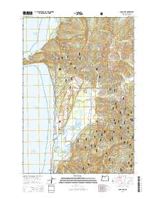
2014 Map of Sand Lake
USGS Topo · Published 2014About this map
Cape Lookout stands as a prominent headland on this Oregon coastline, marking the rugged interface between the Pacific Ocean and the coastal timberlands. The 2014 landscape is defined by the extensive reaches of the Siuslaw National Forest, which blankets the hills and drainages of the Tillamook River and N Beaver Cr. Near the shoreline, the estuary environment of Sand Lake and Whalen Island creates a complex network of marshes and tidelands, while the small settlements of Sandlake and Tierra Del Mar provide the primary human anchors in this coastal region. Local geography is traced through numerous watercourses such as Jewel Cr, Sand Cr, and Whiskey Cr, which flow from high points like Buzzard Butte down to the sea. The map documents a contemporary coastal economy shaped by forest management and conservation, with road networks like Cape Lookout Rd and Sandlake Rd connecting these isolated shoreline communities.
Find a feature on this map
44 named features on this map. Tap any name to fly to it.
Don’t see what you’re looking for? This feature index may not catch every label — zoom into the map to look around manually.
Map Details
Editions of this 2014 Sand Lake Map
This is the sole edition of this map. No revisions or reprints were ever made.
Other maps of this area

1941 · Nestucca Bay
USGS Topo · 1:62,500

1942 · Nestucca Bay
USGS Topo · 1:62,500

1942 · Tillamook
USGS Topo · 1:62,500

1948 · Vancouver
USGS Topo · 1:250,000

1950 · Vancouver
USGS Topo · 1:250,000

1950 · Vancouver
USGS Topo · 1:250,000

1955 · Hebo
USGS Topo · 1:62,500

1955 · Tillamook
USGS Topo · 1:62,500

1958 · Vancouver
USGS Topo · 1:250,000

1964 · Vancouver
USGS Topo · 1:250,000