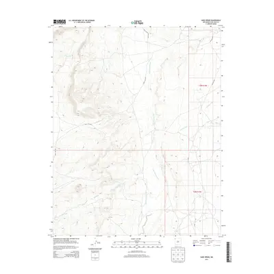
2013 Map of Sand Spring
USGS Topo · Published 2013About this map
Sand Spring and the nearby Sand Springs form the focal points of this arid landscape within the Shiprock Agency region. The drainage pattern is defined by a series of prominent ephemeral watercourses, including the westward-flowing Red Wash and the complex system of Little Shiprock Wash and Shiprock Wash in the eastern half of the quadrangle. These washes indicate the significant impact of seasonal water flow on the local topography, carving paths through the high desert terrain. Human presence is primarily represented by a network of service roads and routes, such as Indian Service Route 5020 and Ind Road 5020, which provide access across the township boundaries of t29n r19w and t28n r19w. The map illustrates the fundamental relationship between sparse water sources and the essential transportation corridors required to navigate this portion of San Juan County.
Find a feature on this map
12 named features on this map. Tap any name to fly to it.
Don’t see what you’re looking for? This feature index may not catch every label — zoom into the map to look around manually.
Map Details
Editions of this 2013 Sand Spring Map
This is the sole edition of this map. No revisions or reprints were ever made.
Other maps of this area

1889 · Chaco
USGS Topo · 1:250,000

1892 · Chaco
USGS Topo · 1:250,000

1892 · Canyon De Chelly
USGS Topo · 1:250,000

1934 · Ship Rock
USGS Topo · 1:62,500

1934 · Rattlesnake
USGS Topo · 1:62,500

1937 · Ship Rock
USGS Topo · 1:62,500

1937 · Rattlesnake
USGS Topo · 1:62,500

1953 · Redrock Valley NE
USGS Topo · 1:24,000

1953 · Redrock Valley SE
USGS Topo · 1:24,000

1953 · Pastora Peak SE
USGS Topo · 1:24,000