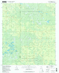
1994 Map of Sanderson Nw
USGS Topo · Published 1998About this map
Reddish Millsite sits near the northern boundary of this landscape, a remnant of former industry in a region dominated by wetlands and conservation lands. The area is defined by the expansive Osceola National Forest and the Osceola State Wildlife Management Area, where the terrain transitions through a series of named islands and dense bays. Features like Negro Camp Island, Noah Island, and Buck Island rise from the surrounding hydrologic network, which includes the formidable Impassable Bay and Pinhook Swamp. The Middle Prong St Marys River clips the southeastern corner, serving as a vital drainage point for the complex swamp systems. Transportation is limited to functional routes such as Sand Hill Road and the Base Line, reflecting the primary use of this land for timber management and wildlife preservation rather than permanent settlement.
Find a feature on this map
18 named features on this map. Tap any name to fly to it.
Don’t see what you’re looking for? This feature index may not catch every label — zoom into the map to look around manually.
Map Details
Editions of this 1994 Sanderson Nw Map
This is the sole edition of this map. No revisions or reprints were ever made.
Other maps of this area

1954 · Valdosta
USGS Topo · 1:250,000

1955 · Council
USGS Topo · 1:24,000

1956 · Eddy
USGS Topo · 1:24,000

1956 · Sargent
USGS Topo · 1:24,000

1958 · Valdosta
USGS Topo · 1:250,000

1959 · Valdosta
USGS Topo · 1:250,000

1961 · Deep Creek
USGS Topo · 1:24,000

1967 · Sargent
USGS Topo · 1:24,000
1967 · Eddy
USGS Topo · 1:24,000

1969 · Sanderson NW
USGS Topo · 1:24,000