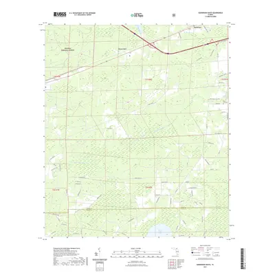
2021 Map of Sanderson South
USGS Topo · Published 2021About this map
Osceola National Forest dominates the northwestern reaches of this Florida interior landscape, where the headwaters of the S Prong Saint Marys River wind through a complex system of cypress strands and wetlands. The settlement of Sanderson sits in the northeast corner, serving as a focal point for a network of local roads that branch out into the surrounding timberlands and swamps. The map captures the distinct boundary where Baker Co meets Union Co in the south, a line crossing through Gumy Bay and near the open waters of Swift Creek Pond.
Find a feature on this map
73 named features on this map. Tap any name to fly to it.
Don’t see what you’re looking for? This feature index may not catch every label — zoom into the map to look around manually.
Map Details
Editions of this 2021 Sanderson South Map
This is the sole edition of this map. No revisions or reprints were ever made.
Other maps of this area

1917 · Macclenny
USGS Topo · 1:62,500

1918 · Lawtey
USGS Topo · 1:62,500

1918 · Macclenny
USGS Topo · 1:62,500

1954 · Valdosta
USGS Topo · 1:250,000

1958 · Valdosta
USGS Topo · 1:250,000

1959 · Valdosta
USGS Topo · 1:250,000

1963 · Olustee
USGS Topo · 1:24,000

1963 · Sanderson South
USGS Topo · 1:24,000

1966 · Lake Butler
USGS Topo · 1:24,000
1966 · Lulu
USGS Topo · 1:24,000