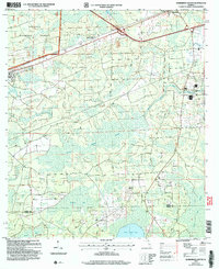
2005 Map of Sanderson South
USGS Topo · Published 2006About this map
Osceola National Forest dominates the northwestern portion of this Baker County landscape, characterized by vast wetlands and the winding headwaters of the St Marys River. The area reflects a rural Florida interior defined by its hydrology, with extensive marshes like South Prong Swamp and secluded water bodies such as Swift Creek Pond, Wampee Bay, and Granny Bay. Human settlement is concentrated along transport corridors, notably at Sanderson and the rail-adjacent Manns Spur. Local history is anchored near the river by the Bethlehem Ch and the adjacent South Prong Cem, providing critical touchpoints for genealogists. The map also captures the specialized infrastructure of the era, including a State Prison and a Mobile Home Park, contrasting the wilderness of the national forest with late-twentieth-century land use and civil boundaries along the Baker Co Union Co line.
Find a feature on this map
16 named features on this map. Tap any name to fly to it.
Don’t see what you’re looking for? This feature index may not catch every label — zoom into the map to look around manually.
Map Details
Editions of this 2005 Sanderson South Map
This is the sole edition of this map. No revisions or reprints were ever made.
Other maps of this area

1917 · Macclenny
USGS Topo · 1:62,500

1918 · Lawtey
USGS Topo · 1:62,500

1918 · Macclenny
USGS Topo · 1:62,500

1954 · Valdosta
USGS Topo · 1:250,000

1958 · Valdosta
USGS Topo · 1:250,000

1959 · Valdosta
USGS Topo · 1:250,000

1963 · Olustee
USGS Topo · 1:24,000

1963 · Sanderson South
USGS Topo · 1:24,000

1966 · Lake Butler
USGS Topo · 1:24,000
1966 · Lulu
USGS Topo · 1:24,000