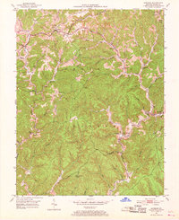
1953 Map of Sandgap
USGS Topo · Published 1968About this map
Sandgap sits at a crossroads of the Kentucky highlands during the early 1950s, serving as a hub for a landscape defined by its network of hollows and ridges. This era captures a rural community structured around local institutions, including School No 1 and School No 2, and churches such as Birch Lick Ch and Lettered Rock Ch. The terrain is dominated by the Cumberland National Forest, where a Fire Lookout Tower stands as a sentinel over the deep drainage basins of Horse Lick Creek and Clover Bottom Creek. The settlement patterns follow the winding watercourses, with small communities like Waneta and Hurley established near the junctions of branches and forks. This map reveals a way of life where geography dictated the placement of every schoolhouse and chapel, from the Cavanaugh Sch in the north to the Upper Indian Cr Sch near the forest interior.
Find a feature on this map
42 named features on this map. Tap any name to fly to it.
Don’t see what you’re looking for? This feature index may not catch every label — zoom into the map to look around manually.
Map Details
Editions of this 1953 Sandgap Map
3 editions found

Other maps of this area

1891 · Manchester
USGS Topo · 1:125,000

1892 · Richmond
USGS Topo · 1:125,000

1892 · Beattyville
USGS Topo · 1:125,000

1893 · London
USGS Topo · 1:125,000

1897 · Richmond
USGS Topo · 1:125,000

1897 · London
USGS Topo · 1:125,000

1952 · Alcorn
USGS Topo · 1:24,000

1952 · Leighton
USGS Topo · 1:24,000

1952 · Bighill
USGS Topo · 1:24,000

1953 · Johnetta
USGS Topo · 1:24,000